John Newman originally delivered this lecture to members of the Wye Historical Society (WHS) in 2017. We are grateful to John for giving us permission to reproduce an edited version of his lecture. We are also grateful to Wye Historical Society for their provision of the historic photographs and to Margaret Newman for providing the contemporary photographs.
Council Housing in the 20th Century
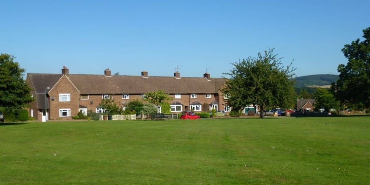
Churchfield Way, was and is a unique development when compared with most twentieth century council estates, in that it maintains a strong visual relationship with the open country beyond. It is also remarkable in being grouped round a large and much valued green. The houses are arranged in short terraces of two, four or six units, and there is further variety in the interplay of gables, mansard roofs and chimney-stacks.
The concept of council housing – homes built by local councils and let to low-earning residents at affordable rents – goes back to the late Victorian period. London County Council became famous for its high-quality housing estates. After the First World War there was a boom in building ‘homes for heroes’ and from the early 1920s all councils, urban and rural, were made responsible for the replacement of slum housing.
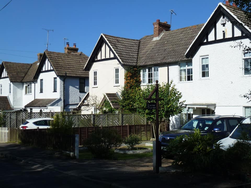
In Kent, East Ashford Rural District Council, under which Wye came, engaged in council house building in the inter-war years. Some local examples are Nos. 24-34 Olantigh Road, Nos. 35-55 at the lower end of Bridge Street, and Pottery Cottages, Naccolt (dated 1927). Each group consists of no more than eight or ten cottages, arranged as rows of semi-detached pairs, so that each cottage has a front garden and ready access to a large back garden.
Post War need for housing
In December 1943, East Ashford R.D.C. began to make plans for a fresh wave of council housing and construction of new houses in ten parishes was approved, including a group of six in Bramble Lane, Wye. The architect responsible for their design was Edwin A. Jackson, rural council housing having became one of the firm’s specialities.
After the end of the War the site in Bramble Lane was proposed for enlargement to take 20 units, but this scheme came to nothing. Instead a new site was found at the far end of Cherry Garden Lane and Jackson & Jackson were commissioned in November 1945 to design eight houses there. Construction started in July 1947 after an eighteen-month delay.
Churchfield Way
The Council then made the strategic decision to concentrate new housing on one major site. Wye was selected as being the village with the best road and rail connections. The fifteen-acre field immediately west of the parish church, the historic church glebe, was ideally sited for a development which could be integrated into the fabric of the existing village. In May 1946 the Rural District Surveyor presented a plan for sixty-two houses plus space for a further fourteen and sixteen reserve sites to be developed by the College or by private individuals.
By good fortune, the preliminary plan survives in the Wye Historical Society’s archives (we believe this to be the plan as the totals of the three sorts of houses tally). The plan of May 1946 is clearly marked as being a preliminary scheme open for discussion, so it is fascinating to see which features of this scheme were eventually carried out and which were completely rethought.
The background to the scheme
The preliminary nature of the first plan suggests the proposed link road being in a straight line extending the High Street westwards, ignoring the gradient down to the river. The extensive green, which is such a striking feature of the executed scheme, is nowhere to be seen; instead the proposed housing is gathered into groups of seven pairs, partly justified by maintaining the line of an existing footpath from Wye Court to Bridge Street. (Eventually the line of this footpath was not maintained, replaced by The Forstal on a new alignment.) Instead of a green, there are three small rectangular spaces with little visual or recreational value.
An explanatory key indicates that the ‘immediate scheme’ concerns 62 houses in 31 pairs, there are 14 houses in a future scheme, while 16 houses are to be built privately. The last were very quickly cancelled, leaving only the 76 proposed council houses. Interestingly the number of houses in the executed Churchfield development is 76.
Comparing the two plans which were considered
In order to focus on the many differences between the preliminary plan and what was eventually executed, it is helpful to step back and consider national thinking on the planning of rural housing. Ideas had begun to change even before the War. The Ministry of Health’s ‘Rural Housing Manual’ published in 1938, had noted ‘the planning of some of the houses in long blocks rather than the semi-detached blocks [i.e. pairs] so much favoured by most housing authorities is of great value in grouping.’ Further official reports and manuals in the mid to late 1940s reinforced this theme and also stressed the value of relating new housing estates to their landscape settings.
The executed scheme, so different from the surviving preliminary plan, clearly reflects acceptance of this new thinking. The first scheme squandered the spaciousness of the 15-acre site.
No preparatory drawings for the executed scheme are known to have survived, but the large-scale ordnance survey map shows the executed plan of the Churchfield development. This shows the importance of symmetry in giving coherence to the layout, a symmetry which the sloping lie of the land effectively disguises.
A photograph (sadly of poor quality), taken from the top of the church tower and published in the Kent Messenger in September 1952 shows the green in the foreground and some of the housing, illustrating its variety. Besides traditional semi-detached pairs, there are terraces of four and of six, one of which has pride of place overlooking the green. The major drawback of the terraces is that external access to the rear of houses in mid-terrace is only by means of a narrow, windowless passage. Eaves gables give external variety, and, as this is still just in the era of coal fires and open hearths, chimney-stacks add further visual incident.
Building Churchfield Way
Site layout
Considerable thought was given to the setting of the houses, doubtless influenced by ‘garden city’ and ‘garden suburb’ ideas. Forest trees were planted on the green, and, while house-construction was still in full swing, a tender for tree planting along the roads was submitted for comments to the Roads Beautifying Association. The front garden of each house was defined by a dwarf brick wall nine inches high. Many of these walls survive. The architects expressed the hope that tenants would enclose front gardens at their own expense with paling fences or hedges, but this happened only rarely. A block of ten lock-up garages was planned. But in the early 1950s few tenants owned cars – the view from the church tower in 1952 shows just one solitary parked car.
Internal layout of the houses
As for internal layout, there are two types of three-bedroom houses: one called ‘kitchen/diner’, where the main living room has a wide hearth for cooking; the other the ‘parlour’ type, with an extra living room. A few bungalows provide two-bedroom accommodation. The average building cost per house was £1,500.
Post war shortage of building materials
The period of construction was still one of post-war austerity. The dull reddish-brown walling bricks give a certain monotony which some tile-hanging or colour-washed render could have transformed. Details such as window lintels and openwork porches are of concrete. The original metal windows have not stood the test of time. All have been replaced in UPVC, more draught-proof but coarser in external appearance.
The merits of the scheme
One of the Churchfield development’s greatest attractions is its low density, seven houses per acre. In 1954, however, two years after completion, the Rural District Council stated that any future development would be at a higher density.
Today the majority of the houses are owner-occupied, and it is a tribute to the original layout and construction that, apart from the UPVC windows and a good many enclosed porches, there has been very little obtrusive alteration.
On completion the estate was warmly praised in the local press. An article in the Kent Messenger of September 1952 gives a shrewd assessment. It is headlined: ‘A model housing estate in the Kent countryside. Bold planning has happy results in Wye development.’ The article notes the pride felt by the staff of East Ashford R.D.C. in its achievement, and calls it ‘a bold venture, planned on what some thought was extravagant lines, simply because it set out to get away from the orthodox, yet at the same time to blend with the rural character of the large parish and also to improve the standard. It is generally accepted that all three objects were achieved and the estate may be described as a “show piece”.’
Sources
W.S. Morris, History and Topography of Wye, H. Chivers, Canterbury (1842) for Wye’s lost green.
Official advice on the siting and planning of council estates in rural settings:
Rural Housing Manual (1938)
‘The Dudley Report’ (1944)
Ministry of Health, Housing Manual (1949)
Advice on the planning of council estates: ‘The Siting of Houses in Country Districts’ H.M.S.O. 1950
Minutes of meetings of East Ashford Rural District Council planning committee, 1943-53, held in Kent Library and History Centre, Maidstone
Manuscript plan of proposed Churchfield development, datable May 1946, held in Wye Historical Society archives
Critique of the Churchfield development on its completion in Kentish Express 4 January 1952, Kent Messenger September 1952 (cuttings held in Wye Historical Society archives)
Obituary of E.A. Jackson FRIBA, founder of Jackson & Jackson, architects, in Kent Messenger 1953 and The Builder vol. 185 p. 958, December 18, 1953


2 Responses
Is there a ‘heritage walk’ or trail around Wye village? We have been enjoying exploring local villages during lockdown and would be grateful if you could signpost a relatively mud free walk to see some of the historic buildings in your lovely village.
Best wishes,
Jane
We do have some walk guides on sale in the Heritage Centre.